MOUNT BROWN AND THE SOURCES OF THE ATHABASCA.1
The Geographical Journal, Vol. V, No. 1 (January 1895), p. 53 - 61
By Professor A. P. COLEMAN, Ph.D., School of Practical Science, Toronto.
THOSE two giants, Mounts Brown and Hooker, which on the maps stand guard over the Committee's Punchbowl in the Athabasca pass, have long had a certain fascination for me. Geographers give them an altitude of nearly 16,000 feet,2 much surpassing any other mountains in the United States or Canada; but there seems no record as to who determined the reputed heights, nor how the work was done. They were named after two distinguished English botanists by Douglas, who crossed the pass in 1820; but having been unable to obtain the copy of the Geographical Society's Journal in which the results of his travels are recorded, I cannot say whether he assigned the heights generally given.
To reach Mount Brown is not so easy as it looks upon the map. An attempt made by a friend and myself by canoe on the Columbia and its [page 54] tributary Wood river failed through an upset in Surprise rapids. A second attempt made with ponies on the eastern flank of the Rockies in 1892 was likewise unsuccessful, partly from the uselessness of the Indian guides employed, and partly from the sickness of a member of the party.
A third expedition, consisting of Mr. Stewart, Mr. L. Q. Coleman, and the writer, with Frank Sibbald as cook and packer, succeeded in reaching and climbing Mount Brown last summer (1893); and it is proposed to give a brief account in this paper of the work done, and the country traversed.
We left Morley, a point on the Canadian Pacific Railway just east of the Rockies, on the 8th of July, and for three days urged our ponies north-westward through the foothills parallel to the Palliser range, a few miles to the south-west. The valleys traversed have the usual muskeg bottoms and grassy sides, dotted with small bushes of willow and knotched-leaved birch; while the hills, 500 to 1000 feet high, are fringed on top and on the moister northern side with poplars and Douglas spruce.
The trail then turned through a "gap" with bare cliffs facing eastward, and followed the Red Deer river, a tributary of the Saskatchewan, into the mountains, traversing a valley, partly wooded and partly prairie, giving charming scenes of river, meadow, and grove backed by moderately lofty mountains. The altitude of Morley is about 4000 feet, and our first camp in the Rockies, at the Mountain Park, was a little below 5000.
The route turns aside from the Red Deer about 10 miles from the gap, across a pass at 6500 feet, and descends to the well-named Clearwater river not far from its exit from the mountains. A mountain near the summit of the pass rises to 6500 feet, and is perhaps a few hundred feet lower than the average of the region.
The Clearwater owes its character to its passage through two pretty lakes not far from its source. These lakes are about 6000 feet above the sea.
After following the Clearwater some miles to the westward, the trail turns north-west once more, passing through narrow valleys and over a pass rising slightly above tree-line (7300 feet). The head waters of Atikosipi are crossed, another pass traversed, and White Rabbit creek is followed down to its junction with the Saskatchewan on the Kootenay plains. These plains, 4600 feet above the ocean, are really an inlet of the prairie3 7 miles long and 2 or 3 wide, having the same sward of green or sere grasses and vetches, or of sag& and wormwood in drier parts.
Sunflowers and flax were in full bloom on the 17th of July, and [page 55] great tufts of harebells made tempting mouthfuls for the ponies as they jogged over the elastic turf, happy to be on level ground once more.
The scenery is admirable, combining the beauty of the prairie with grand mountain forms, the more distant ones white with snow and glaciers. One splendid peak, projecting into the plains on the north of the river, is formed of a great anticlinal fold, au unusual structure in the eastern Rockies, where the prevailing type is of tilted blocks. As this mountain commands views up or down five long valleys, we named it Sentinel mountain. Skulls of buffalo and their numerous trails and wallows, show that the Kootenay plains were once a favourite feeding-ground for these almost extinct animals. According to the Stony Indians, snow never lies here in winter, from the frequent Chinook winds.
The route we had followed thus far is the usual road of the Mountain Stonies toward their more northern hunting-grounds, and has often been traversed by white men. The trail here divides up, one branch turning up-river to Howse pass, by which the Columbia may be reached;4 another down the Saskatchewan toward the plains and Edmonton. The river is already a powerful stream here at its exit from the mountains. In 1892 we found it just fordable for ponies at a point where gravel islands divide it into six channels. Last summer, however, all the rivers were high from the unusually heavy snows of the previous winter, and we found the Saskatchewan quite unfordable, as chief Jonas and. other Indians had forewarned us. We went down-stream till the river flowed in a single channel, swam the horses over, and ferried our stuff with a canvas boat we had brought for such purposes.
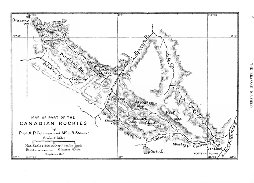
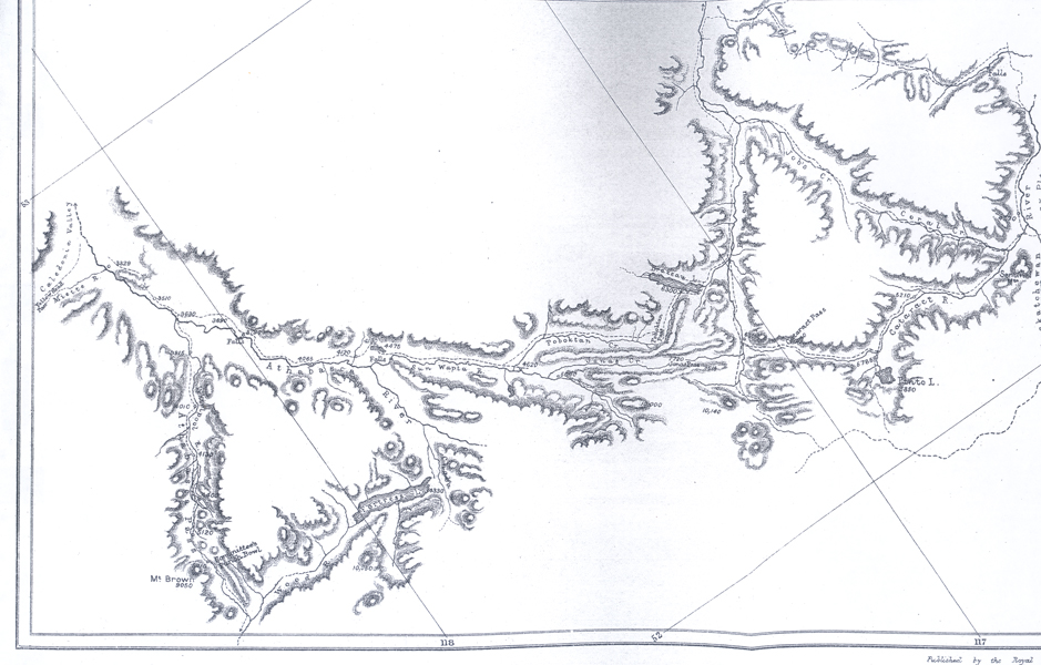
From this point onwards to the Athabasca pass is practically virgin ground. Though a few prospectors have followed up some of the northern tributaries of the Saskatchewan, there is, so far as I am aware, no printed record of their journeys. The route followed by Earl Southesk5 was probably farther to the east, since we could not fit his map and descriptions to the region through which we travelled. Palliser's map proved quite useless. In the previous summer our Indian guides had led us quite astray, taking us out into the foothills and through wretched muskeg trails to the Brazeau. Here we took matters into our own hands, and followed up this river into the mountains again. On our way home we followed a wild pass up Job's creek, and down Rock creek to the Kootenay plains. Last summer we took a more direct route which my brother had used the year before, following up the Hahasigi-wapta, or Cataract river, as the Stony name may be [page 56] translated. This enters the Saskatchewan just at the foot of Sentinel mountains, and is there so deep and swift as to be fordable with difficulty. It takes its source 40 miles to the westward in a delightful lake of blue-green water, cold and trout-haunted, fed by a magnificent spring 40 feet wide. Pinto lake, as we named it, is 5850 feet above the sea. A single range of mountains separates the valley of the cataract from that of the Saskatchewan to the south.
Turning north-west from Pinto lake, we crossed a divide, which may be called Cataract pass, rising 7550 feet above the sea, and made our way down to the Brazeau, one of the largest tributaries of the Saskatchewan. The pass is not an easy one, since snow-slides have mowed down the forest for half a mile in width at one place, and the fallen trunks make a most disheartening obstacle for ponies to cross. At the summit we found so much snow on July 24, that a wide détour up the mountain side was necessary to gain safe footing for our horses. Several glaciers come down to the level of the pass, and one feeds an indigo-coloured pond amidst the snows of the summit. The peaks on each side are of a very bold and rugged character.
A sharp descent of 1200 feet leads to the head-waters of the Brazeau, whose valley is walled in by high mountains of the tilted block or inclined plane type, having steep escarpments toward the north-east, and a slope, following the dip of the strata, of 25° to 50° toward the south-west. A number of the peaks which we climbed rose above 1000 feet, and one at the head of the river reached 10,150. Few or no summits toward the east rise higher than this, but a number of those seen toward the west are much higher.
The previous summer we followed the north fork of the Brazeau up to a lake 5 miles long,6 and then crossed by Poboktan pass7 and creek to the Sun-wapta ; but this year we took a more direct pass suggested by chief Jonas. The trail climbs quickly up through evergreen woods into a narrow desolate side valley, treeless for 7 or 8 miles, and clammy with half-melted snow from a storm the night before, when we crossed it. The descent towards the Sun-wapta leads over muskegs, past beaver ponds, and through horrible burnt woods where the soil has been consumed, leaving sharp stones that roll under the horses' feet on the steep side of the gorge. The pass, which we named for chief Jonas, reaches 7700 feet, and has a rapid descent to the Sun-wapta at 5000 feet. From a height of 10,000 feet on a mountain near by we looked down upon the valley, where the river spreads out into narrow interlacing channels like a skein of ravelled silk flung upon the ground—a common feature of glacial streams near their head-waters. They are perpetually clogging their channels with [page 57] a burden of pebbles and rock flour, through which they must seek new outlets.
Across the valley from our mountain a huge dome-shaped mass of snow, rising much above our level and brooded over by heavy clouds, sent long glacier tongues down into the valley between black precipices. The higher points in the group evidently rose several thousand feet above the one on which we stood. We estimated the highest peaks at 13,000 feet, or perhaps a little more. Dr. Hector gives a similar estimate for the highest summits near Howse pass, 10 or 15 miles to the south-west. We may have been looking at opposite sides of the same mountains.
The Sun-wapta (Stony name) is a large and rapid river, fordable with difficulty at most points, a tributary of the Athabasca not shown on the maps. We followed it down-stream from the mouth of Jonas creek, passing a tremendous rock-slide, where a cubic mile of quartzite has slipped from a mountain on the right shore, damming the river so as to form rapids, and hurling blocks many cubic yards in bulk half a mile up the opposite slope. This event took place not very long ago, for the yellow scar on the mountain has not yet turned grey with lichen growth.
Five miles below Jonas creek we passed the mouth of Poboktan creek, and pushed our way over trails so encumbered with fallen timber as to require much chopping, till the mouth of the Sunwapta was reached. There is a fine waterfall at this point, and a still finer one a few miles farther down on the Athabasca. The united stream, 100 yards wide and quite unfordable, plunges 60 or 70 feet into a very narrow canyon, so narrow that some daring man has flung a few tree-trunks across as a bridge. It is on the whole the grandest falls we saw in the Rockies, though not more beautiful than some in the canyon of the Brazeau.
At last the trail suddenly became well blazed and beaten, unlike previous portions, which cannot have been travelled for several years. We came upon stretches of prairie delightful to behold after weeks of forest. One evening the half bark, half laugh of coyotes drifted up from a distance, delighting the heart of Sibbald, our packer, who is a true plainsman, and declared that it was a decent country where there were coyotes.
After long days of battle with burnt woods, whose charred trunks and branches smear and smudge hands and face and clothing, after night camps pitched between shadeless black trees on a soil of sand and ashes, there is an endless charm in camping on a meadow of soft green grass, beside a brook shaded by clumps of willow.
Following the trail through the woods, we missed the mouth of Whirlpool river, for which we were aiming, and, reaching the Miette a few miles farther down, took it for the river we were in search of. A [page 58] day or two later, the difference in latitude, the wrong direction of the valley, and the finding of railway survey pegs convinced us that we had entered the Yellowhead pass (Tete Jaune), where a survey was made a number of years ago for a projected route of the Canadian Pacific Railway.
A trading post, Henry House, is placed opposite the mouth of the Miette on the maps; but, as we could find no trace of it, probably it has been destroyed and the site overgrown with bushes. The law of the map-maker is apparently that of the consistent Calvinist, "once in grace always in grace." Marks on the trail showed that a party having horses much larger than ours had gone over it a few days before we arrived.
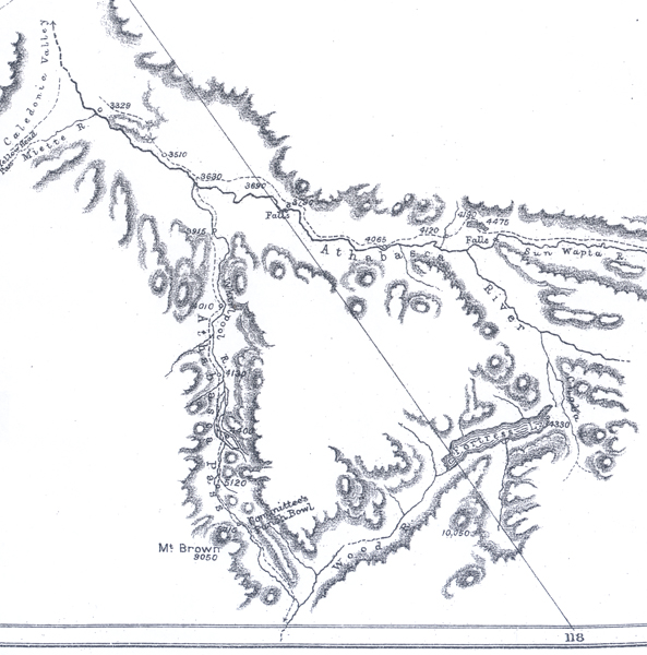
Retracing our steps, we ferried once more across the Athabasca, and followed the impetuous, sea-green Whirlpool river to its source. Once a much-travelled thoroughfare of the Hudson Bay Company and railway explorers, the Athabasca pass has now fallen into disuse. Portions of the trail have been swept away by the river, and many other parts we found impassable without hard chopping.
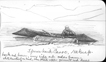
The valley is interesting. At one point a glacier comparable to that of the Rhone sends its blue ice front almost to the level of the river at 4400 feet, and supplies a third of its water. Other large glaciers provide the rest of the flood farther up the valley, until at the watershed the Whirlpool dwindles into an insignificant rivulet rising in a pretty little tarn, the Committee's Punchbowl, which masquerades on many maps as a lake 8 or 10 miles long.8 A rill trickles southward from the other end of the "bowl," which thus divides its snow-fed waters between the Arctic and Pacific oceans at points thousands of miles apart. Moberly gives the elevation of the Punchbowl as 6025 feet, but our observations made it only 5710 feet.
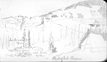
Mount Brown greatly disappointed us. The only summit corresponding to its position on the maps, just west or north-west of the Punchbowl, was climbed by Mr. Stewart and my brother, and turned out to be little, if any, more than 9000 feet high. They found no difficulty in the ascent, except a mile of steep snowfield, until just beneath the summit, where a cornice of snow proved unscaleable. Readings of an aneroid and of a boiling-point thermometer, when compared with readings at camp, give a height of 3340 feet above the pass, or 8950 feet above the sea; and they estimate the thickness of the snow cornice covering the crest at less than 100 feet. From the top no higher mountains were to be seen west of the pass, so that there is no doubt the right mountain was climbed. Mount Brown must descend, then, [page 59] from the position long accorded to it, of being the highest summit in North America between Mexico and Alaska. It has no right to be mentioned in connection with Mount St. Elias in Alaska, nor Orizaba in Mexico, much less with the recently discovered Mount Logan, just east of the Alaskan frontier in the Canadian north-west territory.9
The case of Mount Hooker we found less easy to settle. The point nearest its position, as given on the map, is only about 8000 feet high according to aneroid readings taken by Mr. Stewart and my brother; but a handsome glacier-covered mountain, just east of the Punchbowl, probably reaches 11,000 feet, and there are summits a few miles to the south-east that may reach 12,000 or 13,000 feet, though lack of time prevented their ascent.
The Punchbowl, reflecting gloomy mountain flanks and snowfields, suggested no ideas of conviviality. The little meadow beside it, surrounded by stunted spruce groves, was enlivened with some flowers. Marmots sounded their alarm whistle from behind every rock when any sound, like the chopping of wood, disturbed them. A cinnamon bear walked calmly down into the patch of meadow, surveyed us a moment, and turned courteously into the woods so as not to disturb our privacy. Caribou left their large hoof-prints on the river flats not far away, and mountain sheep and goats doubtless watched us from afar; but the general effect of the surroundings was lifeless and austere.
On our return journey we made a détour to visit Fortress lake, discovered the summer before, and named from a prominent mountain on its shores. We retraced our steps down the whirlpool, turned up the Athabasca, crossing the Sun-wapta near its mouth, and forded the eastern branch of the Athabasca where the river forks. We followed up the western smaller fork, and named it Chaba river, in honour of Job Beaver, an enterprising Stony whose lodge-poles we found in the valley. The name is doubly appropriate, since beavers, though now apparently extinct in the region, were once numerous, as shown by their extensive dams. There are so many Beaver creeks or rivers in north-western Canada that we chose the Stony word, Chaba or Chahba.
Fortress lake, which is 8 miles long by 1 or 2 wide, has waters of pale turquoise blue, fed by a few glacier torrents, and reflects the bare purplish cliffs, the flanks clothed with splendid unburnt evergreen forest, and the glacier-covered summits of some of the finest mountains to be found in the Rockies. The lake has a curious subterranean outlet into a tributary of the Chaba river, but sends most of its water into Wood river, an important affluent of the Columbia ; se that, like the Committee's Punchbowl, it sends its waters to the Pacific [page 60] as well as the Arctic oceans. The lake stands 4330 feet above the sea, and forms the summit of a pass 1400 feet lower than the Athabasca pass 10 or 12 miles to the west, 950 feet lower than the Kicking Horse pass followed by the Canadian Pacific Railway, and 610 feet higher than the Yellowhead pass.
The valley of Fortress lake, belonging as it does to the British Columbian side of the Rookies, shows a richer vegetation than other valleys we had visited. White and black spruce grow to an immense height. A trunk stranded on the shore was 60 feet long, nearly 2 feet thick at the smaller end, and had not yet branched. A few pines grow along the shore, and aspens, balsam poplars, and willows grow on the plain at the head of the lake. The giant cedar and the prickly "devils club," characteristic growths of British Columbia, occur very sparingly. White winter-green and half a dozen other berry-bearing plants thrive in marshy places of the valley, while the rhododendron and the three Rocky Mountain heathers cover wide stretches of the mountain sides. Avalanche tracks, from which the big trees have been swept, grow up with gooseberries, currants, and raspberries, and make favourite haunts of the bears.
Our return route was practically the same as the one followed in coming out, though the Saskatchewan was now fordable, saving us a détour at the Kootenay plains. Apparently no Indians crossed the great river that summer, since we found no traces of them, and but one white man beside ourselves, a prospector named McGavan, whom we ferried over on our way out. The mountains through which we travelled may be said to have no human inhabitants, though a few families of Stonies hunt the sheep there now and then.
To sum up the topography of the Rockies between the Saskatchewan and the Athabasca in a few sentences, we may describe the eastern side of the Rockies as consisting of a series of more or loss steeply tilted blocks facing north-east in precipitous escarpments, and having gentler slopes following the dip of the strata toward the Pacific. They rise to a height of 8000 or 9000 feet toward the east, and 2000 or 3000 feet higher toward the watershed. They are evidently the result of tremendous reversed faults, like those described by McConnell from Bow pass.10 Somewhat rarely these faults are replaced by sharp folds, e.g. Sentinel mount in the Kootenay plains. Eighty parallel ridges result from these faults along the Brazeau, but the number varies in other parts. Running north-west and south-east between these parallel ranges we find a somewhat regular series of longitudinal valleys, generally occupied by creeks tributary to the main rivers, while the latter have cut for themselves larger, less regular, transverse valleys approximately at right angles to the others.
[page 61] At the watershed, on the other hand, we find groups of less regularly disposed mountains, sometimes consisting of nearly horizontal strata and of cathedral shape, rising in their highest summits perhaps above 13,000 feet. The rivers and lakes of this portion of the mountains have not the regularity of direction found in the eastern ranges.
The rocks of the region, so far as can be determined from fossils collected in 1892 and '93, are of Devonian ago, and consist of limestones, shales, and slates, underlaid by thick beds of quartzitic sandstones and conglomerates. The time of elevation is post-Cretacious, since Laramie rocks occur in some of the valleys, as near Brazeau lake, and Cretaceous rocks may be observed tilted into foothills near the Brazeau gap.
Distances were determined by pedometer or dead reckoning, chocked by frequent latitude observations ; heights by means of three aneroids and a boiling-point apparatus, the height of the Athabasca at the mouth of the Miette, which was determined years ago in railway surveys, serving as a check. The readings were compared with sea-level barometer readings for the region, kindly supplied by Mr. Stupart, of the Meteorological Service of Canada. It is believed that the heights determined are not more than 100 or 200 feet astray.
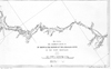
The accompanying carefully executed map is the work of Mr. Stewart.
- 1. Map, p. 96
- 2. Keith Johnston's 'Physical Atlas of Natural Phenomena,' p.26, gives 15,900 feet for Mount Brown, and 15,700 for Mount Hooker. Reclus, in his 'Nouvelle Géographie Universelle,' p. 261, gives the latter mountain a height of 16,980 feet.
- 3. See Dr. Hector's report in 'Captain Palliser's Expedition,' p.111, etc.
- 4. See Mr. Sandford Fleming's 'Expeditions to the Pacific,' in the Roy. Soc. Can. Journals, 1889, Sect. II, p. 89, etc; also Dr. Hector's report in Captain Palliser's 'Exploration in British America.'
- 5. 'Saskatchewan and the Rocky Mountains.'
- 6. Unconnected with any river on those maps which show it at all.
- 7. So named from the owls which we saw on the trees near by.
- 8. Alex. Ross in 'The Fur-Hunters of the Far West,' 1855, vol. ii. p. 188, etc., gives a correct account of the pass, which he crossed in winter.
- 9. In the Am. Geol., Jan. 1894, Mount St. Elias is given a height of 18,015 feet, Orizaba that of 18,315.8 feet. In the number for April, 1894, Mount Logan is represented as 19,514 feet high, far surpassing any other point of North America.
- 10. 'Geol. Sur. Can.,' 1886, vol. ii. D


